Flickring Earth
2012
When I pitched my PhD in 2007, I proposed using other people’s photos in online exhibitions that could help us gain an understanding of time, space and place. Along the way, I wandered off that path towards a more material experience of place using my own found photographs, and the basis of my exhibition is a roll of 36 35mm Tri-X negatives depicting Cronulla Street in 1973. The exhibition is scheduled for 24 September 2012: six months later than originally scheduled because I have taken leave from my program.
I have taken up the opportunity to manage the ARstudio project with the Inspire Centre at the University of Canberra. It is a part time position that will allow me to continue working on my studio practice, since the aims of the ARstudio project fit very well with my interests and experience. One immediate result of the involvement with the project has been the opportunity to collaborate with a new colleague, Paul Krix, to realise some of my earlier plans for online exhibitions. Check out Paul’s Neat Objects website.
One early attempt at a research question for my PhD was Will digital-camera-weilding, broadband-using, Flickr contributors map the world? Combining ideas from David Crandall and his colleagues; David Troy’s FlickrVision (which doesn’t appear to work anymore for me, but that’s probably because I’ve turned off Flash); Ahti Heinla’s World Touristiness Map; and some artist whose name I can’t find again who developed a work by pasting a whole lot of physical prints from around the world on a wall, making the shape of a world map, I came up with the idea of Flickring Earth.
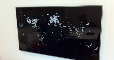
I gave Paul a rough specification for a work that would harvest recent, geocoded, ‘interesting’ photos from Flickr, and print 10 pixel square picons of the photos mapped by their geotags to a black field on the screen. The image above was captured of the first run of the work to see how it was performing, a part of the iterative design collaborative process that Paul and I are using to develop the work. There will be another screen that streams the full-sized images for about 4 seconds each, along with data and information on the image and its contributor.
I’m really pleased with the results so far. It’s great to see my ideas come to life, with Paul’s contributions as well. It’s done using Processing, and we will open-source the results when we are done, although the load on Flickr might not make us very popular if lots of people take the project up.
This is still very much a work-in-progress, with lots of issues to resolve and questions to answer. Eventually, the picons fade away, referencing the ephemeral nature of these insubstantial images. How long we leave them there hasn’t been decided: it will be determined by memory requirements, processing power, as well as the impact of the work.
We use (by my specification) Flickr’s ‘interestingness’ metric to make our initial selection. There are, it seems, exactly 500 photos deemed ‘interesting’ each week day, fewer on weekends, it appears, so there is probably some human intervention in the process. Flickr says that
There are lots of elements that make something 'interesting' (or not) on Flickr. Where the clickthroughs are coming from; who comments on it and when; who marks it as a favorite; its tags and many more things which are constantly changing. Interestingness changes over time, as more and more fantastic content and stories are added to Flickr.
It looks like about 180 out of the 500, around 35%, are geocoded, so to make up the map we go back day-by-day adding geocoded interesting images from each day to build up the work. The work will run continuously, so each new day, when a new crop of interesting photos become available, we will add those to the map. Hopefully we will be able to display this metric (the percentage of each day’s interesting photos that are geotagged).
I would like to run the work online, but we have (read: Paul has) to work out how to present such a dynamic work online without overloading Flickr’s patience with the calls required to make it work.
Still lots of exciting iterations to come. Drew suggested running on a touch screen so a viewer could click the individual picons and see them larger; selected regions (eg, just Australia, or even Sydney — this would require harvesting more than just ‘interesting’ photos).
When it’s done, it will run in the Inspire Centre at the University of Canberra, whenever we can get access to the resources to run it.
Flickring Earth
18/02/12
Beta of Flickring Earth, a work that depicts the overwhelming flow of images that confront us today on the internet. Running on the wall of Rob’s office in the Inspire Centre, University of Canberra.